Archifdy Ceredigion Archives
ACM: Early maps of Cardiganshire
Acc. 3392
Ref: ACM/52-63BOWEN'S SURVEYACM/52Emanuel Bowen, 'A New and Accurate Map of South Wales containing the Counties of Pembroke, Carmarthen, Cardigan, Glamorgan, Brecknock and Radnor, wherein are exactly laid down and delineated from an actual survey and admeasurement; all the towns, villages, churches, chapels, gentlemen's-seats together with the rivers, roads, divisions, mountains, forests, mines, bridges, lakes, fens, &c. in their true position situation and distances' (1760), printed for Carington Bowles in St Paul's Church Yard... Price 10s. 6d.
Topography indicated by developed molehills, small lakes shown at sources of Wye and Severn (see ACM/36. The map depicts novel places and features including New Key Point, Castell Nadolig, the park at Crosswood, other gentry seats, including Millfield at Lampeter, Devil's Bridge, the 'Welsh Potosi' (Esgair Hir) lead and silver mines, the Abbey ruins at Strata Florida, 'a House of Entertainment' and several fishponds. Also depicts several additional routes to those shown on ACM/34. Border marked off to show longitude and latitude, which differ significantly from those indicated on ACM/ 33 (1714) and ACM/ 38 (1748).
Reprint of 1729 publication, dated to 1766 on reverse.
Six sheets c. 159 x 120 cm overall
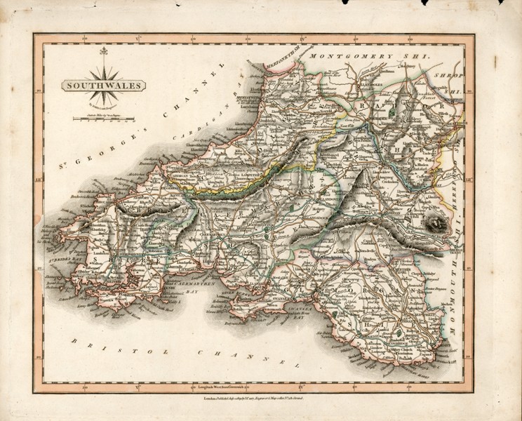
ACM/53'South Wales, by John Cary, engraver', 'London: published July 1809 by J. Cary, engraver & map seller No. 181 Strand'
Reduced copy of Bowen's 'New and Accurate Map of South Wales', ACM/52.
31 x 25.4 cm
ACM/53 (1809)
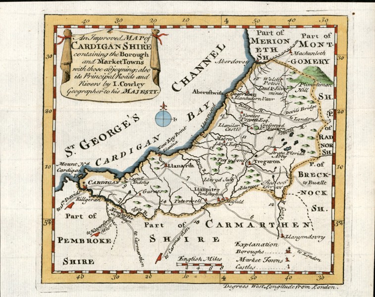
John Cowley, 'An Improved Map of Cardiganshire containing the Borough and Market Towns with those adjoining; also its Principal Roads and Rivers', in R. Dodsley and J. Cowley,
The Geography of England / A New Sett of Pocket Maps (1744/45). Also shows parks and forests. Relief indicated by 'molehills'. Coloured.
Derived from Bowen's survey.
M.G. Lewis No. 36.
19.1-3 x 15.2 cm
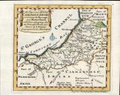
ACM/54 (1744)
Thomas Kitchin, 'A Map of Cardiganshire Drawn from an Actual Survey', in
London Magazine (1754). Indicates parliamentary representation and shows different classes of road, rivers, lakes, forests and principal places and places of interest, with key and the arms of Cardigan. Relief indicated by 'molehills'.
Kitchin was apprenticed to Emanuel Bowen from 1732
Based on Bowen's survey.
M.G. Lewis No. 39.
25.6 x 21.3 cm
ACM/56Thomas Kitchin, 'A Map of Cardiganshire Drawn from an Actual Survey', in P. Russell,
England Displayed (1769).
Reprint of previous (ACM/55)
M.G. Lewis No. 46.
36 x 22.1-5 cm
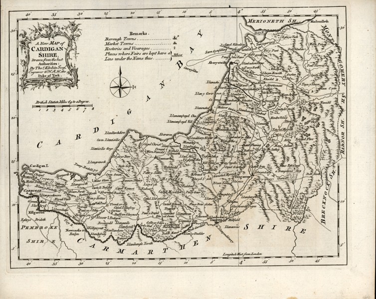
ACM/57Thomas Kitchin, 'An Accurate Map of Cardigan Shire Drawn from an Actual Survey with various Improvements. Illustrated with Historical Extracts relative to its Natural Produce, Trades, Manufactures, Air, Soil, &c. By Thomas Kitchin Geographer'. In collection later known as
The Large English Atlas (1754/1760). Title embedded in bucolic engraving, blocks of text around margins. Shows hundreds, principal routes, with distances, rivers, lakes, forests and woodland, gentlemen's seats and other features of interest. Relief indicated by the developed molehills seen on ACM/52. Coloured
Shows several additional routes to those depicted on ACM/37
Based on Bowen's survey
M.G. Lewis No. 40/41.
58.8-60.4 x 37-37.9 cm
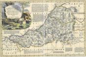
ACM/57 (c. 1754)
Thomas Kitchin, 'An Accurate Map of Cardigan Shire...', printed on same sheet as, 'An Accurate Map of Pembrokeshire', in
The Large English Atlas (1763). Coloured.
Reprint of ACM/57.
M.G. Lewis No. 43.
73 x 57.3 cm
ACM/59Thomas Kitchin, 'An Accurate Map of Cardigan Shire...', printed on same sheet as, 'An Accurate Map of Pembrokeshire', in
The Large English Atlas (1763). Boundaries only coloured.
Reprint of ACM/57.
M.G. Lewis No. 43.
75-75.5 x 58.5-8 cm
ACM/60Thomas Kitchin, 'An Accurate Map of Cardigan Shire...', printed on same sheet as, 'An Accurate Map of Pembrokeshire', in
The Large English Atlas (1763). Boundaries only coloured.
Reprint of ACM/57.
M.G. Lewis No. 43.
71-2 x 55.5-56.2
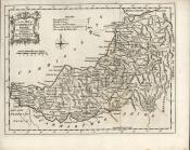
ACM/61?John Gibson, 'Cardiganshire' (1759), identified and dated on reverse with indication that this is a reduced copy of No. 40 (dated 1754) in Lewis's list. Notes and condensed county description printed over sea. Coloured.
Shows same routes as ACM/38 (1748)
Reduced copy of ACM/57
12.8 x 7.9-8.2 cm
ACM/62Thomas Kitchin (now engraver to H.R.H. Duke of York), 'A New Map of Cardiganshire Drawn from the Best Authorities', in
England Illustrated (1764). Parliamentary representation indicated, but not referenced, shows locations of fairs, roads, rivers, lakes, forests and principal places, with key. Relief indicated by 'molehills'.
Provides enhanced details of mouth of Dyfi, including Sarn Gynfelyn (see below, ACM/64 & Maritime, ACM/81)
Derived from Bowen's survey
M.G. Lewis No. 44.
28.6 x 21.1-3 cm
ACM/62 (1764)
'A modern map of South Wales drawn from the latest surveys; corrected and improved by the best authorities', 'Printed for Carington Bowles in St. Pauls Churchyard, & Robt. Sayer in Fleet Street'. Date 1780 in pencil on reverse.
Derived in part from ACM/62
27.6-28 x 22.4 cm